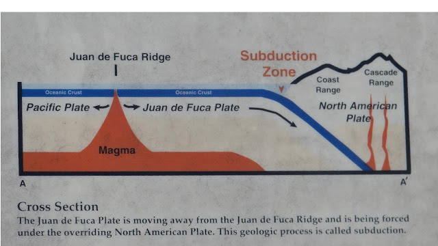
One of the reasons for the tsunami danger is the Cascadia subduction zone, one of the largest active fault in North America. It parallels the coast just 32 - 70 miles offshore.
Below you can see how the Juan de Fuca plate dives under the North American Plate. These graphics were taken from wayside displays near Depot Bay.

What it means for the visitor is that, upon arriving at a state park, you are greeted by signs displaying a map of the camp ground with tsunami escape routes (kind of like fire escape routes in a building). I apologize for the poor quality of the photo, as usual, it was dumping rain on us.
Whne you visit a beach, you will find a map with your location, your odds of being drowned, and what to do to increase your chance of survival. This doesn't exactly make for a relaxing visit...
Street signs marking evacuation routes are ubiquitous..
...there are signs for assembly areas near schools and sports fields....
...and comfortingly reassuring signs when all is safe again.
If you would like to learn more about what it is like to live with the threat of tsunamis, have a look at the state of Oregon's tsunami information clearing house. You will find inundation and evacuation maps and a wide variety of preparedness brochures.


Geologists have measured tsunami debris layers above 300 feet in some locations along the Oregon coast........!
ReplyDeleteI didn't know that. In my mind, when the siren goes off, I take off running...but I guess I'd need to run even further...
ReplyDelete