Hi Everyone,
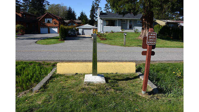
I'm happy to report that we made it to Blaine Washington, the third of the four corners on our trip around the country. In particular, this corner of the country is a park called the Peace Park, which is jointly shared by Canada and the US in celebration of our close and long friendship. This was a beautiful, well groomed park with grass and people sitting out taking pictures. Here I am standing at the Peace Arch. One side is US, the other Canadian.
Here's the WSU sign. Note that as the trip gets longer and longer, my hair gets longer and longer. I'm not sure what the correlation is there.
That arch is the pretty tourist corner. The real corner is a couple hundred feet away, just on the other side of this railroad track in the mud of the bay.
I got to tell you, I had a heck of a time wrapping my head around this. Here I am standing in the US and photographing Canada.
Now, I'm in Canada, photographing the US. Being brave (as you well know), I jumped back and forth between countries and even stood WITH ONE LEG IN EACH COUNTRY. I am, indeed, wicked brave.
So, why is the Mexican border a giant fence with armies of armed guards and dogs patrolling day and night? Here, the US / Canadian border is literally this ditch. I guess that keeps you driving across, but any three-year-old could jump across. If you had a couple 2x12s, you could drive across too.
Ok, while I was doing all this, there was a Border Patrol officer sitting in a Border Patrol SUV about 300 feet away. But....I don't think it is too challenging to cross the US / Canada border without officials knowing. Quite a contrast to the southern border.
Because I love boats and the like, we drove down to the marina, and when I got out and turned around, we saw Mt. Baker, one of the massive volcanoes of the Pacific Ring of Fire. Mt. Baker stands 10,781 feet tall. We decided to drive there the next day.
According to Wikipedia, Mt. Baker is THE SNOWIEST PLACE ON EARTH. It holds the world record of 1,140 inches of snowfall (95 feet or 29 meters) for just one year (1999). The average snowfall is about 600 inches (50 feet or 15 meters). We drove on some tiny roads up to the Mt. Baker ski area, and it started raining. It rained harder, and harder, and harder. You might remember this phenomena as orographic precipitation, which I mentioned in another posting. It just dumped rain on us, and then it began to rain and sleet. The road was very Very VERY narrow, and cut into the cliffside, sloping away down toward oblivion.
Here's what we saw up top. This shows how the road is cut into the snow. The snow bank is slowly thawing and collapsing, you can see some trees bent by the weight of the moving snow. There was a lot of this.
Ski season was closed for the year, so it was just tourists and a few hearty folks at the top slogging up the mountain and skiing down. This picture shows the stratification from the different snow events, and a road sign on the left for scale. You can also see how the top layer is hanging over a bit....
This was one of the better portions of road, where it wasn't cut into the cliff side. It was, however WET.
That's a several stories tall ski lodge, in spring after the snow has been rained on and squished down a lot....
My wife gets angry at me, because I've not got much innate ability to be nervous or scared, and not a whole lot un-nerves me or scares me. Even these incredibly narrow roads with the cracked pavement sloping off over the eroding cliffs didn't scare me too badly.
Turns out what DOES scare me are avalanche areas and snow cornices hanging over the road on VERY rainy days. These pictures don't really convey just how high the snow is, and we don't have pictures of the most overhung areas (probably because Karin had her eyes shut - I did too, but I often do while driving. That's why the narrow bits don't scare me :-o
You can't even begin to get the idea of just how much snow is piled up to the right, in my mind waiting to slide down and push us into space...the first Ford F150 to go into orbit.
Anyhow, I was wicked relieved to get down below the snow line and back to a place where the water was wet, like God intended it to be. You can't canoe or kayak on snow. Least not very well.
Just to remind you that we are in a temperate rainforest, here's what the road looked like when we were low enough for deciduous trees to show up again. I guess the moss was about 6" or more thick on these trees.
What a fantastic couple of days!


You didn't go skiing or sledding???
ReplyDeleteLol
Man it was raining. Right now we're in MT, its raining and sleeting. It has rained on us in every single state so far....
ReplyDelete